


Thunderstorms and Rains Havoc in the North, While Scorching Heat and Humidity Plague the South!
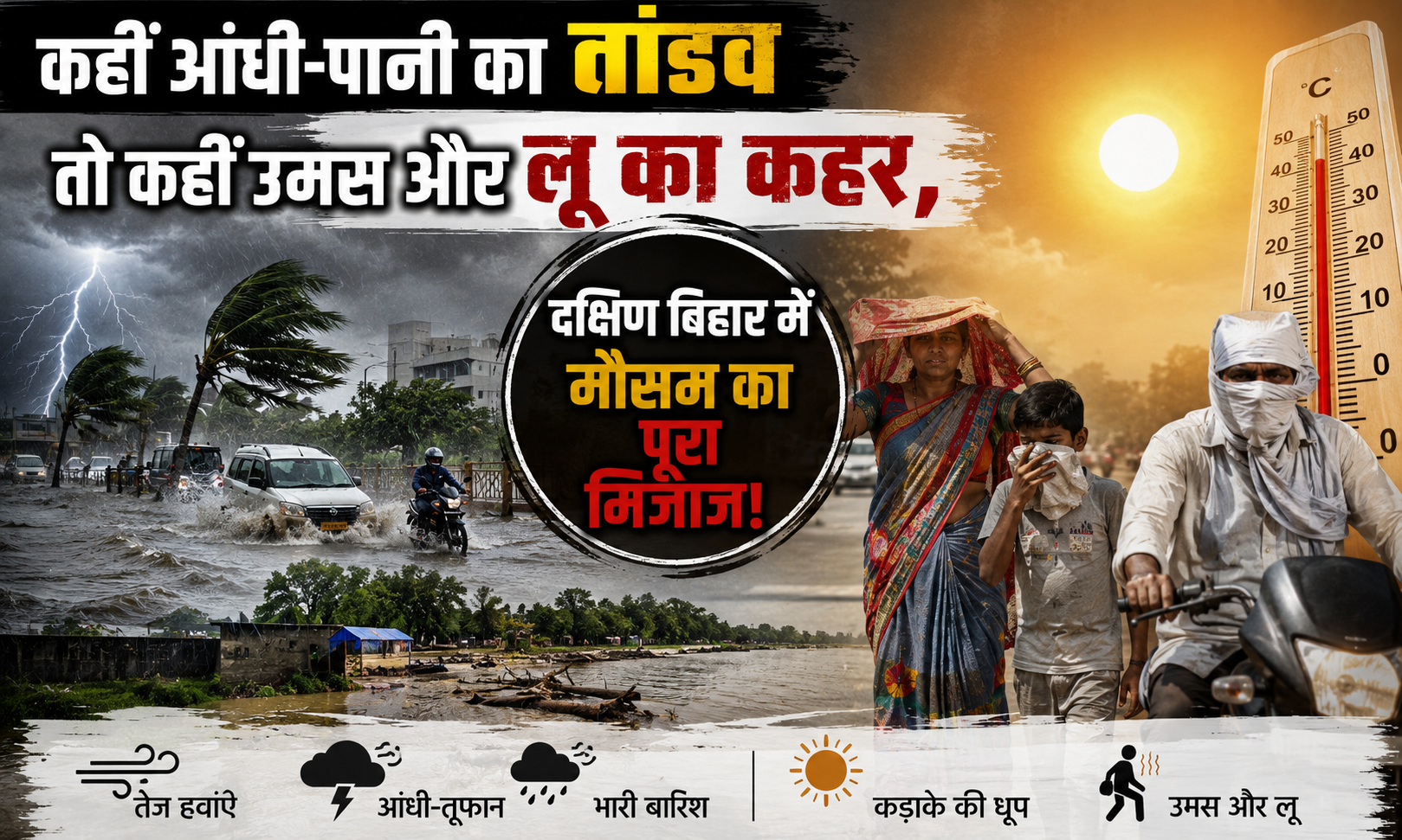
The skies over Bihar are behaving much like a suspense thriller movie lately. Two completely contrasting faces of nature are playing out simultaneously across different districts of the state. On one side, torrential rains and tempestuous winds reaching speeds of up to 70 km/h have turned the weather pleasant in parts of North Bihar and the Seemanchal region. On the flip side, residents in the capital city of Patna and South-West Bihar are facing the brutal double-whammy of severe heatwaves and sticky, suffocating humidity.
According to the India Meteorological Department (IMD) Patna, the state is currently undergoing a sharp 'climate divide.' This phenomenon is triggered by the unique path of the monsoon winds colliding with local weather systems. Here is the comprehensive inside story of Bihar’s current atmospheric split.
South Bihar: The Deadly Combination of Heatwaves and Sticky Humidity
For the districts of South Bihar, this period is proving to be nothing short of a trial by fire. Easterly winds carrying high moisture levels have spiked the humidity, resulting in a sticky, oppressive heat that makes stepping outdoors during the day nearly impossible.
Severe Heatwave Gripping Districts: According to the IMD, South-West Bihar districts including Arwal, Bhabua (Kaimur), Buxar, and Rohtas (Dehri) remain firmly under a heatwave alert. Bhabua recorded a maximum temperature crossing 41.7°C, significantly higher than the seasonal normal.
The Situation in Sheikhpura and Aurangabad: In Sheikhpura, daytime temperatures are hovering up to 7.1°C above normal. The sharp morning sun begins to bake the region by 10 AM, completely disrupting daily life and local businesses.
The 'Real Feel' Factor: While the actual maximum temperature in these plains of South Bihar ranges between 38°C and 40°C, the high humidity makes the 'real feel' temperature scale up to a grueling 45°C.
North and East Bihar: Alerts for Heavy Downpours and Gales
While South Bihar swelters, the monsoon is incredibly generous toward the northern and eastern parts of the state. The landscape here is entirely different.
Gales Tracking at 70 km/h: The IMD has issued a severe weather alert for West Champaran, East Champaran, Sitamarhi, Gopalganj, Saran, Siwan, Muzaffarpur, Darbhanga, and Madhubani. These areas are expected to witness heavy rainfall accompanied by squalls blowing at speeds of 60 to 70 km/h.
Heavy Rainfall Zones: Monsoon clouds are pouring heavily over Bhagalpur, Katihar, Kishanganj, Purnia, Araria, and Supaul. These regions have clocked heavy to very heavy rainfall, resulting in a sharp drop in temperatures and giving residents much-needed relief.
IMD’s Strict Safety Advisory: Weather scientists have issued a stern warning regarding frequent lightning strikes (Vajrapat) during these thunderstorms. Farmers and residents are strictly advised against seeking shelter under tall trees, standing in open fields, or going near riverbanks during active storms.
Capital City Patna: A Game of Hide-and-Seek Between Clouds and Sun
In Bihar's administrative capital, Patna, the weather mood changes by the hour. The day typically starts with a blazing sun and high humidity, but by late afternoon, dark, heavy clouds begin to blanket the horizon.
Marginal Drop in Mercury: Patna's maximum temperature, which was touching the 40°C mark, has eased to around 35°C to 36°C due to cloud cover and intermittent drizzling. The minimum temperature is being recorded around 28°C.
Rain and Wind Forecast: Forecasters project that Patna and its neighboring zones (including Nalanda and Jehanabad) are highly likely to receive steady showers and gusty winds over the next 24 to 48 hours, which should completely clear out the sticky humidity.
The Meteorological Theory: What is Driving This Mismatch?
There is a clear scientific mechanism behind this atmospheric 'double role.' According to IMD Patna, a weather trough (low-pressure zone) is stretching all the way from Haryana across Uttar Pradesh and Bihar down to the Bay of Bengal. Simultaneously, an active cyclonic circulation is amplifying the system.
The Collision of Winds: Moisture-laden easterly winds from the Bay of Bengal are rushing into Bihar's atmosphere, while hot, dry westerly winds are pushing back from the opposite side.
Upcoming Temperature Trends: While the maximum temperature across the state will not shift dramatically over the next 48 hours, a substantial drop of 3°C to 5°C is expected over the following 3 to 4 days. This shift will finally bring relief to the heatwave-struck southern districts as well.
This contrasting duality of weather across Bihar is set to persist for just a little longer. While the south-western districts must remain cautious and shield themselves from the heatwave for another day or two, residents in North and East Bihar must stay vigilant against lightning hazards and localized waterlogging. Forecasters expect the monsoon to become fully and uniformly active across the entire state by the first week of July, triggering widespread rains that will wipe out the remaining summer heat. Until then, stay weather-aware and stay safe.